Watch: Track 'Storm Emma' live as 'the Beast from the East' approaches Ireland
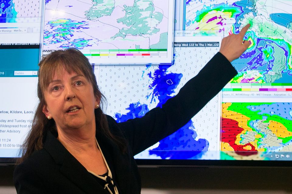
Evelyn Cusack of Met Éireann at the National Emergency Co-ordination Centre, Agriculture House, Kildare St, Dublin. Photo: Gareth Chaney/Collins
The Beast from the East is heading for Ireland and is expected to bring heavy snowfall and blizzard-like conditions.
The live stream, facilitated by Windy.com, allows you to track Storm Emma to see when the 'Beast' is likely to hit your area.
'Beast from the East': Watch LIVE and track the predicted path of Storm Emma across Ireland
Storm Emma: Some communities may be cut off 'for days' as emergency services battle major snow fallsStorm Emma: Some communities may be cut off 'for days' as emergency services battle major snow falls For weather updates click here: http://indo.ie/eSH630iIwDx
Posted by Independent.ie on Friday, March 2, 2018
Note: On some mobile devices you may need the Facebook app installed to view the live stream.
A joined live stream from Tankardstown, Co Carlow is currently showing mild weather, but this is likely to change when snow hits later today.
The first impact of the so-called 'Beast from the East' will be felt this evening, with snow forecast for the east of the country today.
Forecaster Evelyn Cusack told Newstalk Breakfast counties in the east and south will be a "blanket of snow" by Thursday.
"Thursday will be the worst day, and it's not going to be a nice weekend either. I don't want to discount the showers tonight and tomorrow. We're worried about the winds, and there is also the possibility of thunder and lightning with Storm Emma.
"Overall, the west and northwest will fair best. The east and south, they will more than likely be a blanket of snow by Thursday."
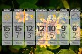
The latest forecast from Met Eireann says the country will wake up to a frosty start today, with scattered showers of snow beginning along the east coast.
The rest of the country will wake up to a bright start but as the day progresses cloud will become widespread and it will bring wintry showers across the country.
Afternoon temperatures will be low, ranging from 3C to 6C and the wind will make it feel even colder.
However, it will be later in the day that the real signs of what is to come will be felt.
'Storm Emma' will come into effect at 3pm on Tuesday and remain in place until 11am on Wednesday.
Snow showers will become more frequent across the east later in the day and tonight will see temperatures plunge to between -2C and -6C, with severe frost, icy patches and snow accumulations as wintry showers are felt across all parts but especially on the eastern seaboard.
Met Éireann is expecting the snowfall this evening and overnight will lead to an accumulation of between 4cm and 6cm by Wednesday morning.
However, the eastern part of the country could see up to 50cm of snow on Thursday and Friday.
A Status Yellow warning is in place for Kilkenny, Longford, Wexford, Offaly, Westmeath, Cork, Tipperary and Waterford from 6.00pm Tuesday to 11.00am on Wednesday.
A Status Yellow weather advisory for the whole country has also been extended and is in place until March 3 at 6.00pm.
This stream will be available throughout the day.
Keep safe and warm, but if you are out in Storm Emma we'd love to see your photos and videos. Send by email to contact@independent.ie or Whatsapp to 0871847169
Join the Irish Independent WhatsApp channel
Stay up to date with all the latest news